Some trails earn their reputation. These are the day hikes and
long-distance routes that draw hikers from every state, chosen for the
places they reach and the stories people bring back from them.
Top Hikes, Park by Park
The five best-known trails in each of thirty national parks —
the most-visited and most iconic in the country. Open a hike to see
what we have on it.
Ten routes — the ones people most often get caught out by
— carry a photograph, a written description, and a lottery or
ticket write-up checked against the park's own permit page. The rest
carry their distance and a one-line description. That is deliberate:
inventing permit rules for a hundred and forty trails would produce a
page that reads authoritative and gets people turned away at a
trailhead.
Entrance fees, opening hours, alerts and current conditions are not
repeated here. Every park card links to that park's profile on the
Discover map, which
holds them in one place and keeps them current, rather than this page
keeping a second copy of the same data in step.
Distances are round trip unless noted, and are approximate. Fees,
lottery dates, and seasonal closures move constantly — confirm
on the official park page before you drive out.
-
-
Alum Cave Trail to Mt. LeConte
11 mi
Iconic climb past Alum Cave Bluffs to the third-highest peak in the park.
-
Charlies Bunion
8 mi
Dramatic rock outcrop along the Appalachian Trail with sweeping ridge views.
-
Laurel Falls Trail
2.6 mi
Paved, family-friendly trail to one of the park's most photographed waterfalls.
-
Rainbow Falls Trail
5.4 mi
Steep hike to an 80-foot waterfall, especially striking after rain.
-
Andrews Bald
3.6 mi
Grassy bald with panoramic mountain views, accessed from Clingmans Dome Road.
View park profile →
-
-
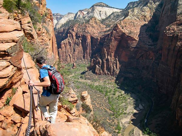
Angels Landing
Chains bolted into sandstone are the only thing between you and a
1,000-foot drop on this white-knuckle ridge walk, rewarded by a
payoff view over Zion Canyon that feels earned in every sense.
The lottery
You need a permit to pass Scout Lookout onto the chained
section. Zion runs two lotteries through Recreation.gov. The
seasonal lottery covers a three-month block of hiking dates and
opens weeks ahead of it, and you rank up to seven day-and-time
preferences. The day-before lottery opens at 12:01 a.m. MT,
closes at 3 p.m., and awards permits at 4 p.m. the
same day. Applying costs $6 for a group of up to six and is
non-refundable; winning adds $3 per person.
-
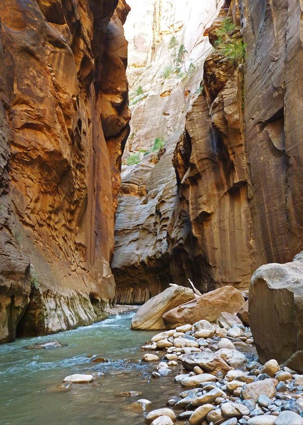
The Narrows
There's no trail here at all, just you, wading upstream through
the Virgin River as thousand-foot sandstone walls narrow overhead
until the sky becomes a ribbon.
-
Emerald Pools Trail
3 mi
Series of pools and waterfalls, easy to moderate difficulty.
-
Observation Point
8 mi, or 6.5 via Zion Canyon overlook route
High vantage point overlooking Angels Landing itself.
-
Watchman Trail
3.3 mi
Sunset-friendly hike near the visitor center with views of the Watchman peak.
View park profile →
-
-
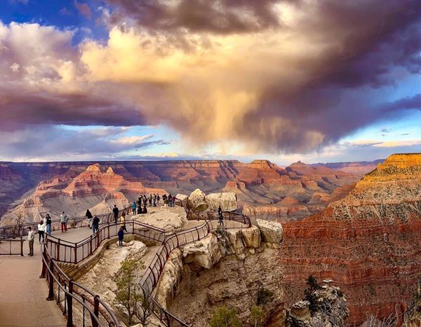
Bright Angel Trail
Switchback down through two billion years of exposed geology,
watching the canyon walls shift color with every thousand feet of
descent.
Before you descend
No permit is needed to day hike, including at night. A
backcountry permit is only required if you sleep below the rim:
$10 per application plus $15 per person per night below the rim,
awarded by a lottery that opens roughly four months ahead. Water
on the trail is seasonal and subject to pipeline breaks, so check
its status at the visitor center or Backcountry Information
Center rather than assuming. The park's own warning is blunt: do
not try to hike from the rim to the river and back in one day,
especially between May and September, when the heat turns
life-threatening fast.
-
South Kaibab Trail
varies, to Ooh Aah Point ~1.8 mi or Skeleton Point ~6 mi
Ridge-line trail with some of the best panoramic views.
-
Rim Trail
up to 13 mi, mostly paved
Easy, accessible walk along the South Rim with continuous views.
-
Hermit Trail
varies
Less crowded, more rugged descent for experienced hikers.
-
North Kaibab Trail
North Rim, varies
Descends into the canyon from the quieter North Rim.
View park profile →
-
-
Emerald Lake Trail
3.2 mi
Passes Nymph and Dream Lakes en route to a stunning alpine lake.
-
Sky Pond
9.4 mi
Strenuous hike past waterfalls to a glacially carved alpine lake.
-
Bear Lake Loop
0.8 mi
Easy, scenic loop and popular trailhead hub.
-
Longs Peak (Keyhole Route)
14.5 mi
Grueling but iconic summit of the park's highest peak.
-
Chasm Lake
8.4 mi
Dramatic lake beneath the east face of Longs Peak.
View park profile →
-
-
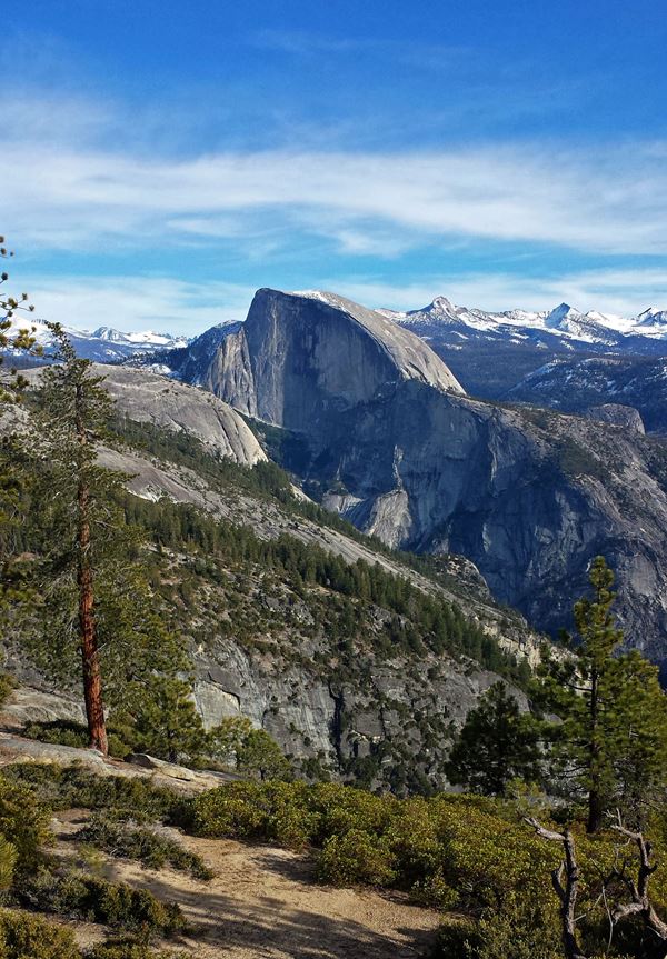
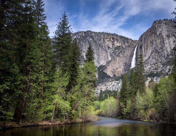
Half Dome
The final 400 feet up steel cables to the summit of this granite
monolith is less a hike than a rite of passage, delivering a
bird's-eye view of the entire Yosemite Valley.
The lottery
Permits are required every day the cables are up, typically the
Friday before Memorial Day through the day after the second
Monday in October. About 225 day-hiker permits go out per day,
inside a 300-person daily cap that also covers backpackers. The
preseason lottery takes applications through March with results
in mid-April; a daily lottery redistributes cancellations two
days ahead, open midnight to 4 p.m. Pacific. The $10
application fee is non-refundable, but the $10 per-person fee is
refunded if you cancel the day before or the cables never go up.
Permits are not transferable: the named holder has to be with
the group.
-
Mist Trail to Vernal & Nevada Falls
Two waterfalls thunder within a few miles of each other here, and
on a hot day the spray off Vernal Fall is as much a part of the
trail as the granite steps beneath your feet.
-
Yosemite Falls Trail
7.2 mi
Climb to the top of North America's tallest waterfall.
-
Four Mile Trail
9.6 mi
Ascends to Glacier Point with classic valley views.
-
Mirror Lake Loop
5 mi
Easier, family-friendly trail with reflective views of Half Dome.
View park profile →
-
-
Grand Prismatic Overlook Trail
1.6 mi
Elevated view of the park's famous rainbow-colored hot spring.
-
Mount Washburn
6.4 mi
Panoramic summit hike, popular for wildlife (bighorn sheep) sightings.
-
Fairy Falls Trail
5–6 mi
Waterfall hike near Grand Prismatic Spring.
-
Uncle Tom's Trail
0.5 mi, steep stairs
Close-up view of the Lower Falls in the Grand Canyon of Yellowstone.
-
Lamar Valley trails (various)
Popular for wildlife viewing (wolves, bison) rather than a single named summit.
View park profile →
-
-
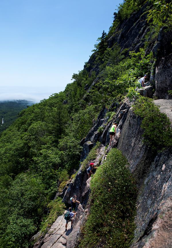
Precipice Trail
Iron rungs and ladders bolted straight into granite cliffs make
this the most exhilarating (and vertiginous) way to reach an
Atlantic coastline summit.
-
Beehive Trail
1.4 mi
Short, exposed scramble with rungs and ladders to great coastal views.
-
Cadillac Mountain North Ridge Trail
4.4 mi
Summit the highest point on the U.S. Atlantic coast.
-
Jordan Pond Path
3.3 mi
Easy loop around a scenic pond with views of "The Bubbles."
-
Ocean Path
4.4 mi
Flat, scenic coastal walk past Thunder Hole and Otter Cliff.
View park profile →
-
-
Delta Lake Trail
8.8 mi, unmaintained spur
Steep but hugely popular hike to a turquoise alpine lake beneath the Tetons.
-
Jenny Lake Loop / Hidden Falls & Inspiration Point
5.3 mi or shorter via boat shuttle
Classic falls-and-viewpoint hike.
-
Taggart Lake Trail
3.3 mi
Moderate hike to a glacial lake with mountain reflections.
-
Cascade Canyon Trail
9+ mi
Scenic canyon hike popular for wildlife and wildflowers.
-
Phelps Lake Overlook (Death Canyon Trailhead)
1.8 mi
Short hike with a rewarding lake viewpoint.
View park profile →
-
-
Hidden Valley Trail
1 mi
Easy loop through a boulder-ringed valley, iconic Joshua Tree scenery.
-
Ryan Mountain Trail
3 mi
Steady climb to one of the best panoramic viewpoints in the park.
-
Barker Dam Trail
1.3 mi
Easy loop past a historic water tank and petroglyphs.
-
Lost Palms Oasis Trail
7.2 mi
Desert hike to the park's largest fan palm oasis.
-
Skull Rock Trail
1.7 mi
Short, family-friendly loop past the famous skull-shaped rock formation.
View park profile →
-
-
Hoh River Trail (to Five Mile Island)
10 mi
Walk through temperate rainforest along the Hoh River.
-
Hurricane Hill Trail
3.2 mi
Paved, high-alpine trail with views of the Olympic Mountains and Strait of Juan de Fuca.
-
Sol Duc Falls Trail
1.6 mi
Short, popular hike to a picturesque three-way waterfall.
-
Marymere Falls Trail
1.8 mi
Easy forest walk to a 90-foot waterfall near Lake Crescent.
-
Ozette Triangle
9.4 mi
Coastal loop combining boardwalk forest trail and wild Pacific beach.
View park profile →
-
-
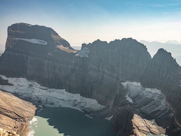
Grinnell Glacier Trail
Turquoise lakes carved by ancient ice lead to a front-row seat at
one of the last glaciers in the Lower 48, a landscape racing
against time.
-
Highline Trail
11.8 mi, often shuttled one-way
Iconic ledge trail along the Garden Wall with sweeping views.
-
Avalanche Lake Trail
5.9 mi
Popular family hike through cedar forest to a stunning alpine lake.
-
Hidden Lake Overlook Trail
2.7–5.4 mi
Short hike from Logan Pass with classic Glacier scenery.
-
Iceberg Lake Trail
9.7 mi
Hike to a glacial lake often dotted with floating icebergs.
View park profile →
-
-
Navajo Loop Trail
1.3 mi
Steep descent through switchbacks among hoodoos, including "Wall Street."
-
Queens Garden Trail
1.8 mi
Easiest way down into the amphitheater, often combined with Navajo Loop.
-
Fairyland Loop
8 mi
Longer loop through less-crowded hoodoo formations.
-
Peekaboo Loop Trail
5.5 mi
Below-the-rim loop through dense hoodoo terrain.
-
Rim Trail
up to 5.5 mi one-way
Easy walk along the canyon rim with continuous overlooks.
View park profile →
-
-
Brandywine Gorge Trail
1.4 mi
Loop past Brandywine Falls, the park's signature waterfall.
-
Ledges Trail
2.2 mi
Rock ledges and overlooks through forest terrain.
-
Blue Hen Falls Trail
1.5 mi
Short hike to a scenic waterfall.
-
Towpath Trail (various sections)
Flat, historic canal towpath popular for walking and biking.
-
Buttermilk Falls Trail
2 mi
Quieter waterfall hike in the park's southern section.
View park profile →
-
-
Old Rag Mountain
A boulder-scrambling rock maze near the summit turns this Blue
Ridge classic into a full-body puzzle, capped by one of the best
panoramic views east of the Mississippi.
Requires a day ticket
From March 1 through November 30 you need an Old Rag day-use
ticket, $2 per person, and it is a separate transaction from the
park entrance pass you still have to buy. Eight hundred tickets
are issued per day: 400 released 30 days ahead and 400 released
5 days ahead, both at 10 a.m. through Recreation.gov. Bring
a photo ID and a printout or screenshot of the ticket.
-
Hawksbill Summit Trail
2.9 mi
Short climb to the highest point in the park.
-
Dark Hollow Falls Trail
1.4 mi
Popular, easily accessible waterfall hike.
-
Stony Man Trail
1.6 mi
Short hike to one of the best overlooks along Skyline Drive.
-
Whiteoak Canyon Trail
4.6–7.3 mi
Series of cascading waterfalls along a scenic canyon.
View park profile →
-
-
Delicate Arch Trail
3.2 mi
Iconic hike to the park's most famous freestanding arch.
-
Devils Garden Loop (to Landscape Arch)
1.9 mi, or 7.9 mi full loop
Passes multiple arches including the longest in the park.
-
Windows Loop
1 mi
Easy loop past North and South Window and Turret Arch.
-
Double Arch Trail
0.6 mi
Short walk to a striking twin-arch formation.
-
Balanced Rock Trail
0.3 mi
Quick loop around a giant balanced boulder formation.
View park profile →
-
-
Hickman Bridge Trail
1.8 mi
Short hike to a large natural bridge.
-
Cassidy Arch Trail
3.4 mi
Climb to a viewpoint atop a scenic sandstone arch.
-
Grand Wash Trail
4.4 mi
Walk through a wide canyon wash, popular for its narrows.
-
Capitol Gorge Trail
2 mi
Easy canyon walk past historic pioneer inscriptions.
-
Chimney Rock Loop
3.6 mi
Loop trail with views of the park's colorful rock formations.
View park profile →
-
-
Mesa Arch Trail
0.7 mi
Short, extremely popular sunrise hike to a cliff-edge arch.
-
Grand View Point Trail
2 mi
Easy walk to one of the best overlooks in the park.
-
Upheaval Dome Overlook Trail
1.6 mi
Short hike to view a striking crater-like geologic feature.
-
Chesler Park Loop (Needles District)
11 mi
Longer hike through dramatic sandstone spires.
-
Whale Rock Trail
1 mi
Short scramble to a panoramic viewpoint in the Island in the Sky district.
View park profile →
-
-
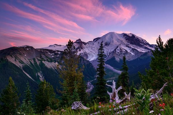
Skyline Trail
Wildflower meadows explode into color each summer against the
backdrop of Rainier's glaciers, close enough that you can hear
ice groaning as it shifts.
-
Naches Peak Loop
3.2 mi
Scenic subalpine loop trail near Chinook Pass.
-
Burroughs Mountain Trail
varies, up to 9 mi
High-elevation trail with close-up views of the mountain.
-
Comet Falls Trail
3.8 mi
Steep hike to one of the park's tallest waterfalls.
-
Tolmie Peak Trail
6.5 mi
Hike to a lookout with views of Eunice Lake and Mount Rainier.
View park profile →
-
-
Congress Trail
2 mi
Paved loop past the General Sherman Tree and other giant sequoias.
-
Moro Rock Trail
0.5 mi, steep stairs
Short climb up a granite dome with sweeping Sierra views.
-
Tokopah Falls Trail
3.9 mi
Hike along the Marble Fork to a tall granite-walled waterfall.
-
Crescent Meadow Loop
"the Gem of the Sierra"
Easy loop through a lush meadow surrounded by sequoias.
-
Big Trees Trail
0.6–1.3 mi
Easy, accessible loop introducing giant sequoia groves.
View park profile →
-
-
Zumwalt Meadow Loop
1.5 mi
Easy, scenic loop along the Kings River in the canyon floor.
-
Mist Falls Trail
9.2 mi
Popular hike to one of the largest waterfalls in the Sierra Nevada.
-
General Grant Tree Trail
0.5 mi
Short loop to the second-largest tree in the world.
-
Don Cecil Trail (to Sheep Creek/Lookout Point)
varies
Steep canyon-wall climb with panoramic views.
-
Roaring River Falls Trail
0.3 mi
Quick walk to a powerful waterfall chute.
View park profile →
-
-
Golden Canyon to Zabriskie Point Trail
2.7–6 mi
Popular badlands hike with colorful canyon walls.
-
Mosaic Canyon Trail
3.5 mi
Narrow canyon hike through polished marble walls.
-
Natural Bridge Trail
1.4 mi
Short hike to a large natural rock bridge.
-
Badwater Basin Salt Flats Walk
varies, up to 2 mi
Flat walk onto the lowest point in North America.
-
Telescope Peak Trail
14 mi
Strenuous summit hike to the highest point in the park.
View park profile →
-
-
Anhinga Trail
0.8 mi, boardwalk
Short, wildlife-rich boardwalk loop famous for alligator sightings.
-
Gumbo Limbo Trail
0.4 mi
Easy loop through dense hardwood hammock forest.
-
Pa-hay-okee Overlook Trail
0.16 mi
Short boardwalk to a sweeping "river of grass" view.
-
Mahogany Hammock Trail
0.4 mi
Boardwalk loop through a jungle-like hammock with a giant mahogany tree.
-
Shark Valley Loop
15 mi, often biked
Long paved loop to an observation tower with wildlife viewing.
View park profile →
-
-
Sliding Sands (Keonehe'ehe'e) Trail
up to 11 mi round trip into the crater
Iconic descent into the volcanic crater.
-
Pipiwai Trail
4 mi
Rainforest hike past bamboo groves to Waimoku Falls (Kīpahulu District).
-
Halemau'u Trail
7.4–8 mi to the crater floor
Cliff-edge trail descending into the crater from the north.
-
Hosmer Grove Trail
0.5 mi
Short nature loop through a planted forest near the summit.
-
Kuloa Point Trail (Pools of 'Ohe'o)
0.5 mi
Easy coastal loop past cascading pools.
View park profile →
-
-
Kīlauea Iki Trail
3.3 mi
Descend into and cross a solidified lava lake crater.
-
Crater Rim Trail (sections)
Rim-edge walking with views into Halemaʻumaʻu Crater.
-
Devastation Trail
1 mi
Easy paved walk through an area devastated by a 1959 eruption.
-
Thurston Lava Tube (Nāhuku) Trail
0.5 mi
Short walk through a large lava tube cave.
-
Pu'u Loa Petroglyphs Trail
1.4 mi
Coastal hike to one of Hawaii's largest petroglyph fields.
View park profile →
-
-
Notch Trail
1.5 mi
Short but exciting hike including a ladder climb, ending at a canyon-view overlook.
-
Door Trail
0.75 mi
Easy walk through a break in the Badlands Wall into the formations.
-
Window Trail
0.25 mi
Very short walk to a natural "window" viewpoint into an eroded canyon.
-
Castle Trail
10 mi
Longest maintained trail in the park, traversing the Badlands Wall.
-
Saddle Pass Trail
0.25 mi, steep
Short, steep connector trail up the Badlands Wall.
View park profile →
-
-
Petroglyph Point Trail
2.4 mi
Loop passing ancient rock art along the canyon rim.
-
Cliff Palace Trail
0.25 mi, ranger-guided
Short but iconic hike to the park's largest cliff dwelling.
-
Balcony House Trail
0.6 mi, ranger-guided, includes ladders
Adventurous tour involving tunnels and ladders.
-
Spruce Canyon Trail
2.4 mi
Loop into a forested canyon below Spruce Tree House.
-
Soda Canyon Overlook Trail
1.2 mi
Easy walk to views of Balcony House across the canyon.
View park profile →
-
-
South Rim Trail
12–14.5 mi
Strenuous loop with the park's most expansive desert and mountain views.
-
Window Trail
5.6 mi
Popular descent through Oak Creek Canyon to a pour-off "window" view.
-
Santa Elena Canyon Trail
1.7 mi
Short hike into a dramatic 1,500-foot canyon along the Rio Grande.
-
Lost Mine Trail
4.8 mi
Popular Chisos Mountains hike with panoramic views.
-
Boquillas Canyon Trail
1.4 mi
Easy riverside walk into another scenic Rio Grande canyon.
View park profile →
-
-
Fern Canyon Loop
1 mi
Short walk through a lush, fern-covered canyon (featured in Jurassic Park 2).
-
Tall Trees Grove Trail
4 mi, permit required
Hike to a grove of some of the tallest trees on Earth.
-
Lady Bird Johnson Grove Loop
1.4 mi
Easy loop through old-growth redwoods.
-
James Irvine Trail
12 mi one-way, often combined with Fern Canyon
Redwood forest trail to the coast.
-
Boy Scout Tree Trail
5.6 mi
Quieter old-growth trail to a large double redwood tree.
Official park page →
-
-
Cascade Pass Trail
7.4 mi
Classic climb to a high mountain pass with glacier and peak views.
-
Thunder Knob Trail
3.6 mi
Easier hike with views over Diablo Lake.
-
Sourdough Mountain Trail
11.2 mi
Strenuous climb to a historic fire lookout.
-
Blue Lake Trail
4.4 mi
Popular hike (just outside the park boundary in the adjacent National Forest) to an alpine lake.
-
Diablo Lake Trail
7.6 mi
Forested trail along the turquoise waters of Diablo Lake.
View park profile →
-
-
Savage River Loop
1.7 mi
Easy, accessible trail along a glacial river, one of the few maintained trails in the park.
-
Mount Healy Overlook Trail
5.4 mi
Steep climb near the entrance with views over the Nenana River valley.
-
Horseshoe Lake Trail
2.1 mi
Easy loop to an oxbow lake, good for wildlife spotting.
-
Triple Lakes Trail
9.5 mi
Longer trail connecting the entrance area to three small lakes.
-
Eielson Alpine Trail
varies, near Eielson Visitor Center, mile 66
Tundra hike with close-up Denali views (requires shuttle bus access).
View park profile →
-
-
Mount Washington via Tuckerman Ravine
Home to some of the wildest weather on Earth, this alpine ravine
climb is New England's ultimate test of grit, still holding snow
well into summer.
Not a national park
Mount Washington sits in White Mountain National Forest, managed
by the US Forest Service rather than the National Park Service,
so no NPS permit data applies to it. No permit is required to
hike Tuckerman Ravine, but trailhead parking fees do apply, and
the ravine is avalanche terrain for much of the year. Read the
forecast before you commit to the headwall.
Official forest page →
5 Most Popular Thru-Hikes
Thru-hike permits work nothing like day-hike permits. These routes cross
dozens of agencies, and only the Pacific Crest Trail has a single permit
covering the whole thing — everywhere else you assemble them
section by section. Details below are curated from each trail's managing
organisation rather than from the NPS API, which has no concept of a
multi-agency trail.
-
1
Georgia to Maine · 14 states
Appalachian Trail
More than 2,190 miles of hardwood forest, granite summits, and
small-town hospitality thread together fourteen states, making it
the grandfather of American long-distance hiking.
Permits, section by section
There is no single trail-wide permit for the AT. You collect them
as you go: a Great Smoky Mountains thru-hiker permit ($44.50), a
Shenandoah backcountry permit ($9 per person plus a $6
reservation fee), and a free Long Distance Hiker Permit from
Baxter State Park, picked up in person within a week of your
Katahdin summit. White Mountain backcountry sites run about $10 a
night. The Appalachian Trail Conservancy also runs a voluntary
thru-hiker registration through ATCamp and strongly encourages it,
mostly to spread start dates out.
-
2
Mexico to Canada · 2,650 miles
Pacific Crest Trail
From desert to alpine to volcanic wilderness, this 2,650-mile spine
along the West Coast is a masterclass in ecological contrast, and
the trail that turned thru-hiking into a household dream.
One permit, if you go long enough
The PCT is the rare trail with a single permit for the whole
route: a PCT Long-distance Permit from the Pacific Crest Trail
Association covers travel and camping along the trail for one
continuous trip of 500 miles or more, which is what makes a
thru-hike administratively possible across dozens of agencies.
Start-date slots are limited and released in application rounds,
so the date you want may already be gone. It does not cover
everything — some segments and side trips still need their
own permits, so check the portal before relying on it end to end.
-
3
Mexico to Canada · 3,100 miles
Continental Divide Trail
The wildest and least-finished of America's Triple Crown trails,
this 3,100-mile route along the Rockies rewards those willing to
navigate by instinct as much as by markers.
Voluntary registration, then real permits
The CDT Coalition's registration is free and voluntary, and it is
explicitly not a permit. It feeds usage data to the Coalition and
its land partners, signs you up for closure and reroute alerts,
and shows you when others are starting so departures spread out;
the first 1,000 registrants get a trail hangtag. Permits are
still assembled piecemeal: a Blackfeet Nation recreation permit to
cross the reservation near Glacier, Glacier wilderness camping
($10 plus $7 per person per night), Yellowstone backcountry ($3
per person per night, in person within 48 hours of entry), Rocky
Mountain ($26 per person per night, hard-sided bear canisters
required), and short permitted stretches in the Indian Peaks
Wilderness. Budget five to seven months.
-
4
High Sierra, CA · 211 miles
John Muir Trail
Widely regarded as the most beautiful 211 miles in America, this
High Sierra route stitches together granite peaks, alpine lakes,
and star-drenched nights above 10,000 feet.
It hinges on your entry trailhead
The permit that decides your trip is the wilderness permit for
whichever trailhead you start from, and Yosemite's are
quota-controlled. Sixty percent of each day's quota is reservable
24 weeks out through a lottery that runs about six months ahead;
the remaining 40 percent opens seven days before. Unclaimed
lottery slots go first-come-first-served from the Friday after the
application period closes. Half Dome needs its own permit on top
of the wilderness permit, even for backpackers already holding
one. Bear canisters are required; Yosemite rents them at the
Valley Welcome Center.
-
5
Vermont · 272 miles
Long Trail
The country's original long-distance trail, this 272-mile ridgeline
traverse through Vermont's Green Mountains is a rugged,
root-tangled love letter to New England wilderness.
Fees are collected on the trail
There is no trail-wide permit to apply for here. The Green
Mountain Club has maintained the Long Trail since 1910 and looks
after roughly 70 backcountry campsites along it, some staffed by
caretakers who collect an overnight fee on site. The Club also
asks hikers to stay off the ridgeline during spring mud season,
when the treadway is easiest to damage — check current
shelter fees and closure guidance before you plan a start date.
Before you go
Several of these hikes need a permit, a timed-entry reservation, or a
lottery entry, and conditions on the exposed and cable-assisted routes
change fast with weather. Check the official park page for current
closures, permit windows, and forecasts before you set out. You can
look up any national park, its live conditions, and its permit portal
on our Discover page.